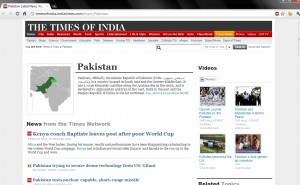
Courtesy Bhaskar Chatterjee, I stumbled on this “map” on a section of the the ToI website:
Might this be a strawman / trial balloon to see how a solution that makes the LoC as a permanent border is received by the public? or am I reading too much into this?
I remember the days when such a map in an Indian publication would have led to copies of the magazine/newspaper being confiscated and/or banned and the offending map censored. I also remember one of the first “official” letters I wrote in the IFS, soon after joining the Embassy of India many years ago. It was to protest against a similar map that was printed in the Japan Times (this was 1994). But I guess times have changed.
Related Post: Has anyone else seen a smilar map? and Google Maps and Disputed Borders
